You can have an accurate fuel tax credit claim and still feel uneasy about it.
The number adds up and the methodology is sound. But if someone asked you to point to the activity behind it, to show that the off-road percentage reflects where your vehicles actually went, could you? For a lot of operators the honest answer is "not easily." The data exists, but it lives somewhere you can't really look at it.
That gap between having the number and being able to see what's behind it is where confidence quietly leaks away. And it's the gap we've been working to close.
The part everyone already agrees on
There's no shortage of advice telling you an FTC claim should be evidence-backed. We've written plenty of it ourselves.
We've covered what it takes to build a defensible claim rather than a best-effort estimate. We've walked through what happens when the ATO comes calling, including the uncomfortable moment when an auditor asks you to explain a split your records can't support.
So we'll take all of that as read. The principle is settled enough by now: good FTC depends on real activity, not assumptions.
What none of those pieces could do was show you the part that makes it click.
Why seeing changes things
A percentage in a report is an abstraction, even when it's a correct one.
"Thirty-eight percent off-road" tells you a fact, but it doesn't let you recognise anything. You can't look at it and think, yes, that's the haul road behind the south site, that's the depot, that's the stretch where our trucks run private the whole way. It's a conclusion handed to you, and you either trust it or you don't.
There's a reason that matters more than it sounds. When the only thing you have is a figure, checking it means going back to the source data and reconstructing the logic, which is slow, technical work that most people quietly decide not to do. So the number goes unquestioned, and not because anyone is confident it's right. It goes unquestioned because confirming it is more effort than it's worth, which is a long way from trust. If anything it's closer to resignation.
Seeing the same information on a map is a different experience entirely. When your fleet's actual movement is in front of you, plotted where it happened, you stop trusting the number and start recognising it. You're looking at your own operation, on roads you know, in patterns that match what your drivers tell you. The off-road activity isn't a figure anymore, it's a place you can point to.
And recognition is fast. You don't need to be a data analyst to look at a map of your own fleet and notice that something is off, or to confirm that it all looks exactly as it should. The check that used to require digging through exports becomes something you can do at a glance. It's the difference between collecting data and actually putting it to work: verification moves from a specialist task to something anyone who knows the operation can do.
That shift, from being told to being able to see, is what turns an accurate claim into a confident one. Nothing about the underlying data changes. What changes is your relationship to it, and how easily you can satisfy yourself that it's right.
Where it matters most
This lands hardest around the public versus non-public road distinction, because that's usually the part doing the most work in a claim and the part you can see the least.
Whether a stretch of travel counts as off-road often comes down to a classification applied automatically, behind the scenes, against base mapping you never see. Most of the time that's fine. But base maps don't always know about a private haul road or a temporary site access route. We've seen this play out in a real client case: a mixed-fleet operator whose construction roads weren't in the base mapping, so genuinely off-road activity was treated as public-road use, and credits were quietly lost as a result.
If you run vehicles in forestry, mining, or agriculture, this is your claim we're talking about. The private roads, the paddocks, the forestry tracks, the sites that never touch a public road, that's not an edge case for you. It's often the bulk of the entitlement. And until now, you've largely had to take the classification on faith.
Think about what that faith actually rested on. A road was either in the base map or it wasn't, and if a new coupe was opened up last quarter, or a haul route shifted as a site developed, the mapping behind your claim might be describing a version of your operation that no longer exists. You'd have no easy way to know. The percentage would still look reasonable, the claim would still lodge, and the gap between the map and the ground would sit there unnoticed.
Being able to look at it changes that. You can see which travel was counted as off-road, check it against what you know to be true, and catch the places where the map and reality don't line up, before they cost you, rather than after.
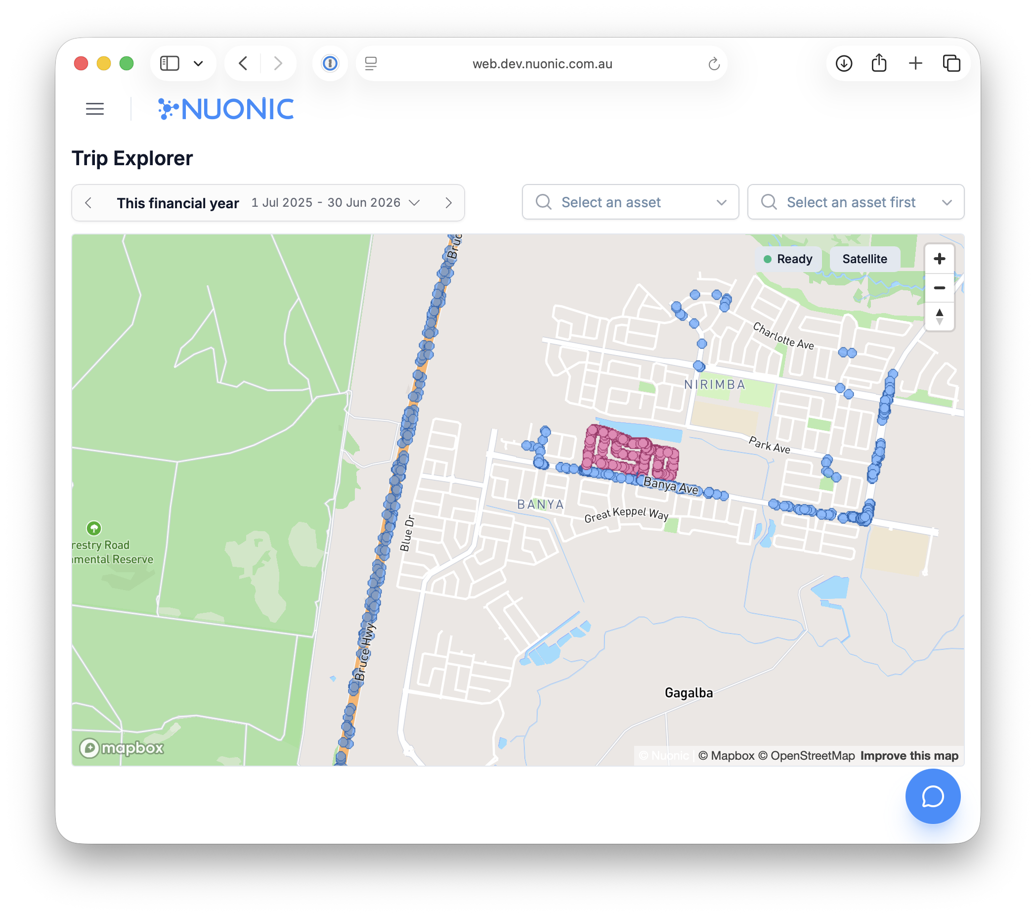
This is what we built Trip Explorer to do
Trip Explorer is a new interactive map inside Nuonic that plots your fleet's GPS activity, so you can see where your vehicles have actually been.
You can look across your whole fleet for any period, narrow it down to a single vehicle or a single trip, and see which parts of the travel have been classified as non-public road. The data that used to sit out of reach in telematics systems and reports is now something you can open up and look at.
It's the same data that's always been behind your claim, except now you can see it. The number stops being something you hope is right and becomes something you can stand behind, because you've looked at where it comes from.
The bottom line
Confidence in a fuel tax credit claim was never really going to come from a better calculation.
It comes from being able to see what the calculation is built on, to recognise your own operation in the data and know that the number reflects it. That's the piece that's been missing all along, and it isn't better maths. It's just the ability to look at what you've got.
Which is most of what believing your own claim comes down to.